MS Book and Mineral Company
Tristate Mining District Catalog
Home Page
Contact information
Fossil Specimens
Mineral Specimens
Place an Order
Sale
Mining History Illustrations
Tristate Mining District: Located in Arkansas, Kansas, Missouri, and Oklahoma
Recent additions to this catalog are noted in this color
Abbreviations used below: pb, an original paper covered document; pc, photocopied and bound in paper as original; pdf, digital copy on cd;
SIR, a USGS Scientific Investigation Report; SIM, a USGS Scientific Investigation Map
Books & Maps
Andrews, W. J., et.al. / SELECTED METALS IN SEDIMENTS AND STREAM IN THE OKLAHOMA PART OF THE TRISTATE MINING DISTRICT 2000-2006, 2009, USGS SIR 2009-5032, pb, 36 pages, 18 figs., 7 tables, $ 24 [The abandoned Tri-State mining district includes 1,188 square miles in northeastern Oklahoma, southeastern Kansas, and southwestern Missouri. The most productive part of the Tri-State mining district was the 40-square mile part in Oklahoma, commonly referred to as 'the Picher mining district' in north-central Ottawa County, Oklahoma. The Oklahoma part of the Tri-State mining district was a primary producing area of lead and zinc in the United States during the first half of the 20th century. Sulfide minerals of cadmium, iron, lead, and zinc that remained in flooded underground mine workings and in mine tailings on the land surface oxidized and dissolved with time, forming a variety of oxide, hydroxide, and hydroxycarbonate metallic minerals on the land surface and in streams that drain the district. Metals in water and sediments in streams draining the mining district can potentially impair the habitat and health of many forms of aquatic and terrestrial life. Lakebed, streambed and floodplain sediments and/or stream water were sampled at 30 sites in the Oklahoma part of the Tri-State mining district by the U.S. Geological Survey and the Oklahoma Department of Environmental Quality from 2000 to 2006 in cooperation with the U.S. Environmental Protection Agency, and the Quapaw and Seneca-Cayuga Tribes of Oklahoma. Aluminum and iron concentrations of several thousand milligrams per kilogram were measured in sediments collected from the upstream end of Grand Lake O' the Cherokees. Manganese and zinc concentrations in those sediments were several hundred milligrams per kilogram. Lead and cadmium concentrations in those sediments were about 10 percent and 0.1 percent of zinc concentrations, respectively. Sediment cores collected in a transect across the floodplain of Tar Creek near Miami, Oklahoma, in 2004 had similar or greater concentrations of those metals than sediment cores collected at the upstream end of Grand Lake O' the Cherokees. The greatest concentrations of cadmium, iron, lead, and zinc were detected in sediments beneath an intermittent tributary to Tar Creek, a slough which drains mined areas near Commerce, Oklahoma. In surface water, aluminum and iron concentrations were greatest in the Neosho River, perhaps a result of runoff from areas underlain by shales. The greatest aqueous concentrations of cadmium, lead, manganese, and zinc were measured in water from Tar Creek, the primary small stream draining the Picher mining district with the largest proportion of mined area. Water from the Spring River had greater zinc concentrations than water from the Neosho River, perhaps as a result of a greater proportion of mined area in the Spring River Basin. Dissolved metals concentrations were generally much less than total metals concentrations, except for manganese and zinc at sites on Tar Creek, where seepage of ground water from the mine workings, saturated mine tailings, and/or metalliferous streambed sediments may be sources of these dissolved metals. Iron and lead concentrations generally decreased with increasing streamflow in upstream reaches of Tar Creek, indicating dilution of metals-rich ground water by runoff. Farther downstream in Tar Creek, and in the Neosho and Spring Rivers, metals concentrations tended to increase with increasing streamflow, indicating that most metals in these parts of these streams were associated with runoff and re-suspension of metals precipitated as oxide, hydroxide, and hydroxycarbonate minerals on land surface and streambeds. Estimated total aluminum, cadmium, iron, manganese, and zinc loads generally were greatest in water from the Neosho and Spring Rivers, primarily because of comparatively large streamflows in those rivers. Slight increases in metal loads in the downstream directions on those rivers indicated contributions of metals from inflows of small tributaries such as Tar Creek and from runoff.]
Bain, H. F. / PRELIMINARY REPORT ON THE LEAD AND ZINC DEPOSITS OF THE OZARK REGION WITH AN INTRODUCTION AND CHAPTERS ON THE PHYSIOGRAPHY AND GEOLOGY BY G. I. ADAMS, USGS Annual Report 22, Volume 2, part 2, 1901, cl, pages 23 - 227, 20 plates, 10 figs., $ 199
Bain, H. F. / PRELIMINARY REPORT ON THE LEAD AND ZINC DEPOSITS OF THE OZARK REGION WITH AN INTRODUCTION AND CHAPTERS ON THE PHYSIOGRAPHY AND GEOLOGY BY G. I. ADAMS, USGS Annual Report 22, Volume 2, part 2, 1901, pb, pages 23 - 227, 20 plates, 10 figs., $ 59
De Hay, K. L. / HYDROLOGY AND GROUNDWATER QUALITY IN THE MINE WORKINGS WITHIN THE PICHER MINING DISTRICT, NORTHEAST OKLHOMA 2002-2003, USGS SIR 2004-5043, 2004, pb, 62 pages, 24 figs., 4 tables, $ 24 [The Picher mining district of northeastern Ottawa County, Oklahoma, was a major site of mining for lead and zinc ores in the first half of the 20th century. The primary source of lead and zinc were sulfide minerals disseminated in the cherty limestones and dolomites of the Boone Formation of Mississippian age, which comprises the Boone aquifer. Ground water in the aquifer and seeping to surface water in the district has been contaminated by sulfate, iron, lead, zinc, and several other metals. The U.S. Geological Survey, in cooperation with the Oklahoma Department of Environmental Quality, investigated hydrology and ground-water quality in the mine workings in the mining district, as part of the process to aid water managers and planners in designing remediation measures that may restore the environmental quality of the district to pre-mining conditions. Most ground-water levels underlying the mining district had similar altitudes, indicating a large degree of hydraulic connection in the mine workings and overlying aquifer materials. Recharge-age dates derived from concentrations of chlorofluorocarbons and other dissolved gases indicated that water in the Boone aquifer may flow slowly from the northeast and southeast portions of the mining district. However, recharge-age dates may have been affected by the types of sites sampled, with more recent recharge-age dates being associated with mine-shafts, which are more prone to atmospheric interactions and surface runoff than the sampled airshafts. Water levels in streams upstream from the confluence of Tar and Lytle Creeks were several feet higher than those in adjacent portions of the Boone aquifer, perhaps due to low-permeability streambed sediments and indicating the streams may be losing water to the aquifer in this area. From just upstream to downstream from the confluence of Tar and Lytle Creeks, surface-water elevations in these streams were less than those in the surrounding Boone aquifer, indicating that seepage from the aquifer to downstream portions of Tar Creek was much more likely. Water properties and major-ion concentrations indicate that water in the mining area was very hard, with large concentrations of dissolved solids that increased from areas of presumed recharge toward areas with older ground water. Most of the ground-water samples, particularly those from the airshafts, had dissolved-oxygen concentrations less than 1.0 milligram per liter. Small concentrations of dissolved oxygen may have been introduced during the sampling process. The small dissolved-oxygen concentrations were associated with samples containing large iron concentrations that indicates possible anoxic conditions in much of the aquifer. Ground water in the mining district was dominated by calcium, magnesium, and sulfate. Sodium concentrations tended to increase relative to calcium and magnesium concentrations. Ground-water samples collected in 2002-03 had large concentrations of many trace elements. Larger concentrations of metals and sulfate occurred in ground water with smaller pHs and dissolved-oxygen concentrations. Iron was the metal with the largest concentrations in the ground-water samples, occurring at concentrations up to 115,000 micrograms per liter. Cadmium, lead, manganese, zinc, and the other analyzed metals occurred in smaller concentrations in ground water than iron. However, larger cadmium concentrations appeared to be associated with sites that have small iron concentrations and more oxygenated waters. This is noteworthy because the small sulfate and iron concentrations in these waters could lead to conclusions that the waters are less contaminated than waters with large sulfate and iron concentrations. Ground-water quality in the mining district was compared with subsets of samples collected in 1983-85 and in 2002. Concentrations of most mine-water indicators such as specific conductance, acidity, magnesium, sulfate, and trace elements concentrations decreased over that period. Calcium concentrations did not significantly change. Mineral saturation indices indicated that the carbonate minerals aragonite, calcite and dolomite, that compose much of the Boone aquifer, were likely to dissolve at most sites. The sulfate minerals of lead (anglesite), barium (barite), cadmium, zinc (goslarite), calcium (gypsum), and iron (melanterite) were generally undersaturated in the ground-water samples, indicating likelihood for dissolution of those minerals and potential for those elements to dissolve into ground water. The clay mineral kaolinite, which is known to form as a hydrolysis product of feldspars at low temperatures, was oversaturated in most of the samples, indicating that it may precipitate out of local ground waters.
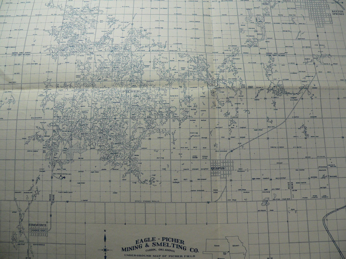
Eagle - Picher Mining & Smelting Company / UNDERGROUND MAP OF PICHER FIELD, Cardin, Oklahoma, January 1, 1946, 14 x 16" blue lines on cream colored stiff paper, needs to be framed upon delivery, only one is available, - 2 -, $ 199 [There are many pdf maps of Picher Field, but this one is special because of the color and the Company which made this map is clearly identified; click jpeg to enlarge]
Haworth, E., Crane, W. R., and Rogers, A. F. / SPECIAL REPORT ON LEAD AND ZINC, University Geological Survey of Kansas Volume VIII, Topeka, 1904, gilt cl, 507 pages, 66 plates, 90 figs., - 5 -, chip to top edge of spine, repairs to hinges, ovg, interior of book exceptionally clean, $ 200 [Book contains both international and historic information on lead and zinc mining; lead and zinc uses; methods and costs of mining, prospecting, and milling lead and zinc ore with an emphasis on the Galena, Kansas to Joplin, Missouri region with historic photographs]
Jakosky, J. J., et.al. / GEOPHYSICAL INVESTIGATIONS IN THE TRI-STATE ZINC AND LEAD DISTRICT, State Geological Survey of Kansas, Bulletin 44, Topeka, 1942, pb, 151 pages, 2 plates, 55 figs., 17 tables, $ 150
Kleeschultz, M. J., Ed. / HYDROLOGIC INVESTIGATIONS CONCERNING LEAD MINING ISSUES IN SOUTHEASTERN MISSOURI, 2008, USGS SIR 2008-5140, pb, 238 pages, 41 figs., 22 tables, $ 49 [Good stewardship of our Nation's natural resources demands that th49 extraction of exploitable, minable ore deposits be conducted in harmony with the protection of the environment, a dilemma faced by many land and water management agencies in the Nation's mining areas. As ore is mined, milled, and sent to the smelter, it leaves footprints where it has been in the form of residual trace metals. Often these footprints become remnants that can be detrimental to other natural resources. This emphasizes the importance of understanding the earth's complex physical and biological processes and their interactions at increasingly smaller scales because subtle changes in one component can substantially affect others. Understanding these changes and resulting effects requires an integrated, multidisciplinary scientific approach. As ore reserves are depleted in one area, additional exploitable deposits are required to replace them, and at times these new deposits are discovered in previously unmined areas. Informed decisions concerning resource management in these new, proposed mining areas require an understanding of the potential consequences of the planned mining actions. This understanding is usually based on knowledge that has been accumulated from studying previously mined areas with similar geohydrologic and biologic conditions. If the two areas experience similar mining practices, the information should be transferable. Lead and zinc mining along the Viburnum Trend Subdistrict of southeastern Missouri has occurred for more than 40 years. Additional potentially exploitable deposits have been discovered 30 miles to the south, within the Mark Twain National Forest. It is anticipated that the observation of current (2008) geohydrologic conditions in the Viburnum Trend can provide insight to land managers that will help reasonably anticipate the potential mining effects should additional mining occur in the exploration area. he purpose of this report is to present a compilation of previously unpublished information that was collected as part of a larger multidisciplinary study of lead mining issues in southeastern Missouri. The report resulted from the application of a multidisciplinary approach to investigate current hydrologic and biologic conditions in streams of the Viburnum Trend and the exploration area in the Mark Twain National Forest.
McHenry, R. E. / CHAT DUMPS OF THE MISSOURI LEAD BELT, ST. FRANCOIS COUNTY, MISSOURI, with an Illustrated History of the Lead Companies that Built them, Marceline, 2006, cl, 400 pages, - 1 -, $ 75 [A complete pictorial history of the Lead Belt of St. Francois County beginning in 1823 with numerous underground photographs, some personal history, but most of the book is dedicated to the mines, mining, railroads, conveyors, smelting, etc.]
McKnight, E. T. and Fischer, R. P. / GEOLOGY AND ORE DEPOSITS OF THE PICHER FIELD, OKLAHOMA AND KANSAS, USGS PP 588, 1970, pb, 165 pages, 11 plates (in slipcase), 10 tables, $ 189
Pope, L. M. / ASSESSMENT OF CONTAMINATED STREAMBED SEDIMENT IN THE KANSAS PART OF THE HISTORIC TRISTATE LEAD AND ZINC MINING DISTRICT, CHEROKEE COUNTY, KANSAS, 2004, USGS SIR 2005-5251, pb, 61 pages, 16 figs., 12 tables, $ 24 [The Tri-State Mining District in parts of southeast Kansas, southwest Missouri, and northeast Oklahoma was the primary source of lead and zinc ore in the world for much of its 120-year history. Commercial mining in the Kansas part of the Tri-State Mining District began in the mid-1870s and lasted until 1970. The environmental degradation caused by 100 years of mining resulted in the U.S. Environmental Protection Agency listing the Cherokee County, Kansas, part of the Tri-State Mining District on its National Priority List as a superfund hazardous waste site in 1983. To assist in the injury determination and quantification step of the natural resource damage assessment for Cherokee County, Kansas, the U.S. Geological Survey in cooperation with the U.S. Fish and Wildlife Service and the Kansas Department of Health and Environment conducted a two-phase study of the occurrence and distribution of contaminated streambed and lake-bottom sediment. Phase I of this study determined concentrations of 28 trace elements and nutrients in streambed sediment at 87 sampling sites in the Spring River and Tar Creek watersheds in Kansas. Phase II determined bottom-sediment concentrations and mass accumulation and historic transport of trace elements into Empire Lake, an impoundment of the Spring River. The purpose of this report is to present the results of phase I of this study. Streambed-sediment samples (98 composite samples) were collected from the upper 0.8 inch of sediment deposition, and the less than 0.063- millimeter (silt- and clay-size particles) fraction was analyzed for selected trace element and nutrient concentrations. Restricting analyses to the silt/clay fraction reduced particle-size induced variability between sampling sites and permitted direct site-to-site concentration comparisons. Concentrations of cadmium, lead, and zinc had much greater ranges in concentrations than any other elements analyzed. Ranges in concentrations were 0.6 to 460 mg/kg (milligrams per kilogram) for cadmium, 22 to 7,400 mg/kg for lead, and 100 to 45,000 mg/kg for zinc, with median concentrations of 13, 180, and 1,800 mg/kg, respectively. Concentrations were largest at sampling sites in the Short, Tar, and Spring Branch Creek watersheds containing the most intensively mine-affected streams. Concentrations of cadmium, lead, and zinc in streambed sediment from sampling sites on the Spring River increased about 18, 7, and 17 times, respectively, within its 22-mile length in the study area. This finding may explain a downward trend in mussel diversity and density over the same length of stream as determined by the Kansas Department of Health and Environment. Estimates of background (pre-mining) concentrations of cadmium, lead, and zinc in streambed sediment for streams in the study area were 0.6, 20, and 100 mg/kg, respectively. However, much of the study area may be contaminated with these trace elements from wind distribution of contaminated dust that was generated during ore milling, processing, smelting, and storage of waste material. On the basis of mollusk species diversity and abundance at sites with cadmium, lead, and zinc concentrations similar to background concentrations, it appears there is only a minimal biological effect.
Schramm, E. F. / REPORT ON ARTEMISA MINES, LTD. LOCATED IN SONORA, MEXICO WITH A DESCRIPTION OF THE ORE DEPOSITS, Denver, 1932, pb, 112 pages, well illustrated, some plates in color, - 2 -, $ 30 [Ore body yielded silver, lead, zinc, and a trace of gold; compares ore to Tristate An-Pb mines in Oklahoma, Missouri, and Kansas]
Siebenthal, C. E. / ORIGIN OF THE ZINC AND LEAD DEPOSITS OF THE JOPLIN REGION, MISSOURI, KANSAS, AND OKLAHOMA, USGS 606, 1915, afb, 283 pages, 11 plates, 16 figs., $65; another copy with first 7 pages photocopy replaced, pages slighty stiff, ovg, $ 39
Smith, D. S. / OCCURRENCE, DISTRIBUTION, AND VOLUME OF METALS-CONTAMINATED SEDIMENT OF SELECTED STREAMS DRAINING THE TRI-STATE MINING DISTRICT, MISSOURI, OKLAHOMA, AND KANSAS, 2011-2012, SIR 2016-5144, 2016, pc, 86 pages, 32 figs., 8 tables, $ 24 [Lead and zinc were mined in the Tri-State Mining District (TSMD) of southwest Missouri, northeast Oklahoma, and southeast Kansas for more than 100 years. The effects of mining on the landscape are still evident, nearly 50 years after the last mine ceased operation. The legacies of mining are the mine waste and discharge of groundwater from underground mines. The mine-waste piles and underground mines are continuous sources of trace metals (primarily lead, zinc, and cadmium) to the streams that drain the TSMD. Many previous studies characterized the horizontal extent of mine-waste contamination in streams but little information exists on the depth of mine-waste contamination in these streams. Characterizing the vertical extent of contamination is difficult because of the large amount of coarse-grained material, ranging from coarse gravel to boulders, within channel sediment. The U.S. Geological Survey, in cooperation with U.S. Fish and Wildlife service, collected channel-sediment samples at depth for subsequent analyses that would allow attainment of the following goals: (1) determination of the relation between concentration and depth for lead, zinc and cadmium in channel sediments and flood-plain sediments, and (2) determination of the volume of gravel-bar sediment from the surface to the maximum depth with concentrations of these metals that exceeded sediment-quality guidelines. For the purpose of this report, volume of gravel-bar sediment is considered to be distributed in two forms, gravel bars and the wetted channel, and this study focused on gravel bars. Concentrations of lead, zinc, and cadmium in samples were compared to the consensus probable effects concentration (CPEC) and Tri-State Mining District specific probable effects concentration (TPEC) sediment-quality guidelines. During the study, more than 700 sediment samples were collected from borings at multiple sites, including gravel bars and flood plains, along Center Creek, Turkey Creek, Shoal Creek, Tar Creek, and Spring River in order to characterize the vertical extent of mine waste in select streams in the TSMD. The largest concentrations of lead, zinc, and cadmium in gravel bar-sediment samples generally were detected in Turkey Creek and Tar Creek and the smallest concentrations were detected in Shoal Creek followed by the Spring River. Gravel bar-sediment samples from Turkey Creek exceeded the CPEC for cadmium (minimum of 70 percent of samples), lead (94 percent), and zinc (99 percent) at a slightly higher frequency than similar samples from Tar Creek (69 percent, 88 percent, and 96 percent, respectively). Gravel bar-sediment samples from Turkey Creek also contained the largest concentrations of cadmium (174 milligrams per kilogram [mg/kg]) and lead (7,520 mg/kg) detected; however, the largest zinc concentration (46,600 mg/kg) was detected in a gravel bar-sediment sample from Tar Creek. In contrast, none of the 65 gravel bar-sediment samples from Shoal Creek contained cadmium above the x-ray fluorescence reporting level of 12 mg/kg, and lead and zinc exceeded the CPEC in only 12 percent and 74 percent of samples, respectively. In most cases, concentrations of lead and zinc above the CPEC or TPEC were present at the maximum depth of boring, which indicated that nearly the entire thickness of sediment in the stream has been contaminated by mine wastes. Approximately 284,000 cubic yards of channel sediment from land surface to the maximum depth that exceeded the CPEC and approximately 236,000 cubic yards of channel sediment from land surface to the maximum depth that exceeded the TPEC were estimated along 37.6 of the 55.1 miles of Center Creek, Turkey Creek, Shoal Creek, and Tar Creek examined in this study. Mine-waste contamination reported along additional reaches of these streams is beyond the scope of this study. Flood-plain cores collected in the TSMD generally only had exceedances of the CPEC and TPEC for lead and zinc in the top 1 or 2 feet of soil with a few exceptions, such as cores in low areas near the stream or cores in areas disturbed by past mining.]
Snider, L. C. / PRELIMINARY REPORT ON THE LEAD AND ZINC OF OKLAHOMA, Geological Survey Bulletin 9, Norman, 1912, pb, 96 pages, 16 figs., pb, $ 24
Weidman, S.,THE MIAMI-PICHER ZINC-LEAD DISTRICT, OKLAHOMA, with chapters on mining methods by C. F. Williams, and Milling in the Tristate District by C. O. Anderson, Oklahoma Geological Survey Bulletin # 56, Norman, 1932, pb, 177 pages, 11 plates, 12 figs., - 2 -, $ 49
Winslow, A. / THE DISSEMINATED LEAD ORES OF SOUTHEASTERN MISSOURI, USGS B 132, 1896, pb, 31 pages, 6 plates, 3 figs., $ 48
USGS Publications
PP 24 / Adams, G. I. / ZINC & LEAD DEPOSITS OF NORTHERN ARKANSAS, WITH A SECTION ON THE DETERMINATION AND CORRELATION OF FORMATIONS, 1904, afb, 118 pages, 27 plates, 6 figs., $ 179 [This document covers the area just southest of Joplin, Missouri, and also Galena, Kansas; this area of Arkansas it also directory east of the Tristate area of Indian Territory]
USBM Publications
B 154 / Wright, C. A. / MINING AND MILLING OF LEAD AND ZINC ORES IN THE MISSOURI-KANSAS-OKLAHOMA ZINC DISTRICT, 1918, afb, 134 pages, 134 pages, 17 plates, 53 tables, 13 figs., $ 125 [Contains photographs of mining structures and miners underground, diagrams of mills, and a map of the mines in the Joplin area]
IC 7713 / Brichta, L. C. and Perkins, E. T. / CATALOG OF RECORDED EXPLORATION DRILLING AND MINE WORKINGS IN THE TRI-STATE ZINC-LEAD DISTRICT, MISSOURI, KANSAS AND OKLAHOMA - INTERIM REPORT, pb, $ 100; pc, $ 40
IC 7774 / Clarke, S. S. / MINING METHODS AND COSTS AT THE WESTSIDE MINE OF THE EAGLE-PICHER CO., CHEROKEE COUNTY, KANSAS, 1955, 24 pages, 7 figs., 2 tables, original pb, $ 100; pc, $ 40
IC 7823 / Netzband, W. F. / MINING METHODS AND COSTS AT THE RIALTO MINE, NELLIE B DIVISION, AMERICAN ZINC, LEAD AND SMELTING COMPANY, OTTAWA CO., OKLAHOMA, 1958, pc, 23 pages, 11 figs., 11 tables, pb, $ 100; pb, $ 40
IC 7930 / Elizondo, J. B. / MINING METHODS AND COSTS AT THE PIOKEE MINING UNIT AND THE PIOKEE EXPERIMENTAL MINING PROJECT, THE EAGLE-PICHER COMPANY (TRI-STATE MINES), OTTAWA COUNTY, OKLAHOMA, 1959, pb, 26 pages, pb, $ 100; pc, $ 40
IC 7993 / Brichta, L. C. / CATALOG OF RECORDED EXPLORATION DRILLING AND MINE WORKINGS, TRI-STATE ZINC-LEAD DISTRICT-MISSOURI, KANSAS, AND OKLAHOMA, 1960, 12 pages, 8 figs., 1 table, pb, $ 100; pc, $ 40
RI 4337 / Knox, C. C. / INVESTIGATION OF MELROSE ZINC-LEAD DISTRICT, OTTAWA CO., OKLAHOMA AND CHEROKEE CO., KANSAS, 1948, 92 pages, 22 figs., pc, $ 40
RI 4398 / Ruhl, O. R. and Ballinger, H. J. / INVESTIGATION OF THE ZINC-LEAD DEPOSITS IN HORIZONS BELOW THE GRAND FALLS CHERT, GALENA DISTRICT, CHEROKEE COUNTY, KANSAS, 1949, 119 pages, 4 figs., analysis of 124 drill holes, pb, $ 150; pb, $ 45
RI 4415 / Knox, C. C. / INVESTIGATION OF ZINC-LEAD DEPOSITS ON EXTENSIONS OF THE MIAMI TROUGH, OTTAWA COUNTY, OKLAHOMA AND CHEROKEE COUNTY, KANSAS, 1949, 35 pages, 8 maps, original pb, $ 100; pc, $ 40
RI 4490 / Ruhl, O., Allen, S. A., and Holt, S. P. / ZINC-LEAD ORE RESERVES OF THE TRISTATE DISTRICT, KANSAS AND MISSOURI, 1949, 59 pages, 8 figs., 9 tables, pc, $ 40
RI 4598 / INVESTIGATION OF THE ORONOGO-WEBB CITY-DUENWEG ZINC-LEAD DISTRICT, JASPER COUNTY, MISSOURI, 1950, 84 pages, 11 figs., analysis of numerous drill holes, pb, $ 150; pc, $ 45
RI 4811 / Brichta, L. S. and Allen, S. A. / INVESTIGATION OF MELROSE ZINC-LEAD DEPOSIT, CHEROKEE COUNTY, KANSAS, 1951, pc, 97 pages, 9 figs., 7 tables, pc, $ 40
RI 5426 / Brichta, L. C. and Ryan, J. P. / PRACTICAL EVALUATION OF ELECTRICAL RESISTIVITY SURVEYS AS A GUIDE TO ZINC-LEAD EXPLORATORY DRILLING, BADGER-PEACOCK CAMP AND VICINITY, CHEROKEE COUNTY, KANSAS, 1958, 91 pages, 38 figs., 12 tables, pb, 150; pc, $ 45
RI 5503 / Chester, J. W. / APPLICATION OF ELECTRICAL-RESISTIVITY SURVEYS TO EXPLORATION FOR ZINC-LEAD DEPOSITS, RACINE-SPURGEON AREA, NEWTON COUNTY, MISSOURI, 1959, 57 pages, 31 figs., 5 tables, pb, $ 100; pc, $ 40
USGS Maps
GP 0427 / AEROMAGNETIC MAP OF PART OF THE TRI-STATE MINING DISTRICT, KANSAS, MISSOURI, AND OKLAHOMA, $ 10
End of the Trisate Mining District Catalog!
Click any link to continue....
Home Page
Catalogs on this Website
Mineral Specimens
Mineralogy Books
Select Mineral Books
U.S. State Geology
USGS Publications
Ore Deposits
Paleontology Books